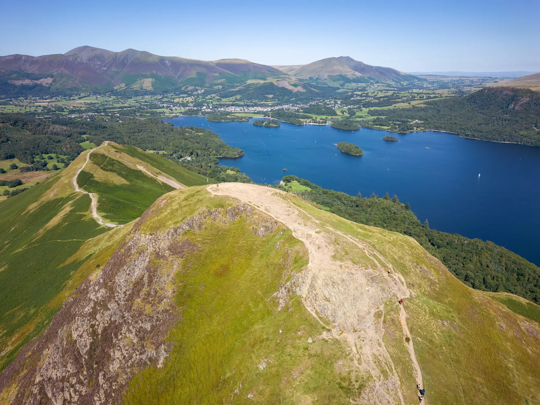
Catbells is the fell everyone in Keswick points at. It sits on the far side of Derwentwater, a 451-metre ridge with a name that looks like a shop and a profile like a child’s drawing of a mountain. Short, shapely and visible from the square: that is why it is the most crowded hill in the northern Lakes, and why doing it badly is so easy.
The walk itself is not the problem. Getting to the start without circling a single-track lane for twenty minutes is the problem. The local answer is the Keswick Launch to Hawes End, and it is the answer for a reason.
This is the Catbells day from town: how to reach the ridge, what the scramble actually is, how to come down, and how to avoid the car park that fills before breakfast.
From the summit you see the whole of Derwentwater and its islands, Keswick under Skiddaw, the Newlands valley opening west, and Borrowdale folding south. Few English hills of this height give you that much geography in one turn. The ridge is also short enough that a reasonably fit walker can be up and down in a couple of hours, which is why families, first-timers and people who “don’t really do mountains” all end up on it.
Mountain Rescue knows the hill because of that last group. In dry summer weather, with decent shoes, Catbells is straightforward. In rain the two rocky steps turn greasy; in winter they hold ice. The people who get into trouble treated “easy” as a guarantee.
The Keswick Launch runs from the town landings, ten minutes on foot from the market square, across to Hawes End on the western shore. The crossing is about ten minutes. You step off the boat at the foot of the ridge.
This is the standard start, not a novelty. It removes the parking scramble on the lane below Catbells, it puts the lake in the day rather than next to it, and it is what regular walkers do. Buy a return if you plan to come back the same way; buy a hop-on ticket if you might walk the shore instead. Boats are frequent in summer, thinner in winter, and they cancel in high wind — check the day’s timetable at the office by the landings before you commit. Dogs go on the boats.
There is sometimes an early walkers’ sailing aimed at this crossing. Treat that as a bonus when it runs, not as a fixture; the published timetable is the thing to trust.
More on the circuit, the other jetties and hire boats is in our Derwentwater guide.
From the landing stage you walk up to the road, along fifty metres or so from the cattle grid, and take the clear path that leaves at the first bend. It zig-zags steeply up the breast of Skelgill Bank, eases, then climbs again to the summit of Catbells.
Keswick Tourism Association’s published circuit is about 3.5 miles / 5.7 km, around three hours including stops, moderate, with a short steep section and some minor scrambling. Other walkers’ timings for the same ground sit between two and two and a half hours of moving time. Allow the longer figure if you have children, want photographs, or are not in the habit of going uphill.
The path is obvious in clear weather. It is a tourist path, not a wilderness, and you will have company on any decent weekend from Easter to October.
There are two rocky steps on the way up. Neither is a climb. Both ask you to use your hands for a few moves, and both have a drop beside them that looks worse than it is until it is wet. People with small children often find a way around or wait for a gap in the traffic. People who freeze on rock sometimes turn round here, which is a perfectly respectable decision.
In the dry, trainers with a grip will do for many walkers, though boots are kinder on the descent. In the wet, the same rock is a different proposition. There is no shame in coming back another day.
The usual continuation is south along the ridge to the saddle at Hause Gate (also called Hawes Gate), where four paths meet. From there a steep made path drops east toward the lake. You can pick up the terrace path above the water and follow it north through the Brandelhow woods, past the old mine workings, back to Hawes End and the boat.
That is the circular. The other option is to stay on the ridge over Maiden Moor if you want a longer day — that is a different walk, and it is not the Catbells most first-timers came for.
You can also drop to the shore and walk all the way back to Keswick instead of waiting for the launch. It is pleasant, it is mostly flat, and it turns a half-day into a full one.
You can walk to Hawes End from Keswick through Portinscale. The Lake District National Park puts the linking walk at about 4 km / 2.5 miles each way, mostly on public footpaths, fields and woodland, essentially flat. Lingholm, Nichol End and Portinscale all offer a cup of tea on the way back.
It is a good option when the boats are off, or when you want the day to be entirely on foot. It is not a shortcut.
Do not drive to the roadside spaces below Catbells unless you are arriving very early on a quiet day. The lane is narrow, the bays are few, and they are full by half past eight on a fine Saturday. Turning a car around there is a poor way to start a walk.
Park in Keswick instead. Lakeside on Lake Road is closest to the landings. The rugby club on Crow Park Road is used as a park-and-sail: a day’s parking there has, at times, come with a launch discount voucher for the driver and up to four passengers. Confirm that on the day rather than counting on it; offers change.
From Easter to October the Honister Rambler (the 77 / 77A circular) stops at Catbells as part of a loop through Borrowdale, Honister, Buttermere and Whinlatter. It is a genuine alternative to both the boat and the car. Timetables sit on the Stagecoach and Keswick pages; they are seasonal.
For the town car parks, the free edges and the charge points, see parking in Keswick.
On a bank-holiday Saturday in summer the ridge is a procession. Go early, go late, or go in weather that keeps people in the cafés. An evening ascent in June or July — started at five, down in the long light — is a different hill from the same path at eleven in the morning.
The mountain forecast and the town forecast are not the same thing. Catbells is low enough that it is often clear when Skiddaw is in cloud, and low enough that a shower you can see coming from the landings will be on you before you summit. Carry a waterproof anyway. This is Keswick.
Winter is a different sport. The steps ice. The wind on the crest is out of proportion to the height. If you do not have winter kit and the habit of using it, pick Latrigg or the shore path instead — both are in our walks guide.
Dogs are welcome on the launch and on the fell. Sheep graze the open ground, so leads are expected around livestock, and the rocky steps are awkward for some dogs. Know your animal.
Children who like a bit of adventure often love this walk; children who do not like heights sometimes do not. The time to find that out is not on the second step with a queue behind you. Pack more food and more time than the guidebook hours suggest.
Boots or shoes with a real sole, a waterproof, water, a paper map (OS Explorer OL4 covers it), and the willingness to turn round. Main Street will sell you the rest if you arrived without it.
Park once in town. Walk to the landings. Take the boat to Hawes End. Up the ridge, down to Hause Gate, terrace path back to the jetty, boat home. Lunch in town. That is the classic, and it is classic because it is the version that does not fight the geography.
If the boats are off, walk out through Portinscale or take the rambler bus. If the cloud is on the ridge, do not invent a reason to go up anyway — the Brandelhow woods and the western shore are the same boat ride and a better day in the wet. Our rain guide covers the rest of that list.
It is not a wilderness. It is not a scramble in the climbing sense. It is not Skiddaw, and it is not easier than Skiddaw in every respect — Skiddaw is longer and duller; Catbells is shorter and more awkward underfoot. People ask which is easier because the two hills share a skyline and almost nothing else: one is a long grind, the other a short, awkward ridge.
It is, on the right day, the best two hours you can spend above Keswick. The trick is to treat the boat as part of the walk, the scramble as real, and the car park at the bottom of the lane as a trap.